Maps by Anton Thomas
  • Home
  • Shop
  • Story
  • Wild World
  • N. America
  • Videos

Blog

How do you finish a map?

12/21/2019

0 Comments

 
Perhaps it's never finished, you just... stop.
Picture
What a year it has been!

It began with the completion of the map, and now it closes with prints on the brink of a presale release. That's right, you did read that correctly - it's finally happening! At long last, the prints are going on presale very soon - within February 2020. The preorder period will run for a month, before printing and shipping begins later in March.

​I’m communicating about prints most with my email list, so if you’re not on the list and want to know as soon as prints are available, be sure to sign up here.
Picture
So with the map almost on sale and the year winding up, I've been reflecting on 2019 a lot. I wrote a reflection on the year but it's too long for a single blog. Instead, I think I'll release it in chunks. So here's the first part.

This entry goes back to the early part of the year, with the final completion of the map, its very detailed cartouche, what it actually felt like to sign off in that final moment, and the all-important final scan.

The cartouche

I began this year as I had every year since 2015. Entrenched in my studio drawing the map that wouldn’t end.

I was close though. Things were wrapping up. I was drawing seemingly endless sea creatures across a vast bathymetric ocean. I had made star stencils and was setting constellations in the slivers of space in all four corners. I was working off a map completion checklist that was getting smaller by the day.

And then I drew a cartouche...
Picture
The constellations of Ursa Major and Ursa Minor/the North Star grace the polar skies of the northwest corner of the map.
Picture
The cartouche of the North America map. This took longer than some standalone maps I've drawn.
Placed in the Bermuda triangle, it took 150 hours to draw. Given the scale and detail of the map, I felt the cartouche had to do it justice. I wanted it to be emblematic of the project. Plus, I needed a place for the title, and somewhere to sign and date it. But it's very hard to sum up a project that dominated your life for years. If you've been lost wandering its trees for that long, how do you now describe the forest?
​
North America: Portrait of a Continent sits across the top, with a colour grade of Earth tones. The design of the cartouche is exactly that: a portrait of North America. A mini map, same projection, is surrounded by a frame of dense detail. Unlike the endless content of the map proper, the mini map allows North America to simply be. Just coastlines, land cover, faint urban sprawls and bathymetry.
Picture
The “frame” of the portrait is where the action is. A cornucopia of North America encircles, with some of the continent’s most iconic features positioned relative to their location. From the eagle-and-snake of the Mexican coat of arms, to the North Star and inuksuk from Nunavut’s flag, the frame is filled with symbols. It has more than 50 animals, dozens of peaks, and buildings from many different cities. ​

It is kind of a mini, deconstructed version of the main map. Outside of the animals, its details include: Denali, the Grand Canyon, Crater Lake, Big Sur, Grand Teton, redwoods and sequoias, Delicate Arch, the Alamo, the Cabo San Lucas arch, Teotihuacan, Chichen Itza, many volcanoes of Mexico/Central America, an Olmec head, the Chateau Frontenac, Niagara Falls, the Statue of Liberty, the Mississippi-Missouri River, the St Louis arch, a Florida space shuttle, the José Martí memorial in Havana, and the Bridge of the Americas over the Panama canal.

Flags of every sovereign nation on the map are there, clustered mostly in the Central America/Caribbean area. At the bottom, a scarlet macaw holds a banner that contains my basic details. My info is carried by a macaw, because it's the content that holds me up. The reason this map works, the reason I have so much to draw, is because the world is so interesting.


Completing the map, once and for all

Picture
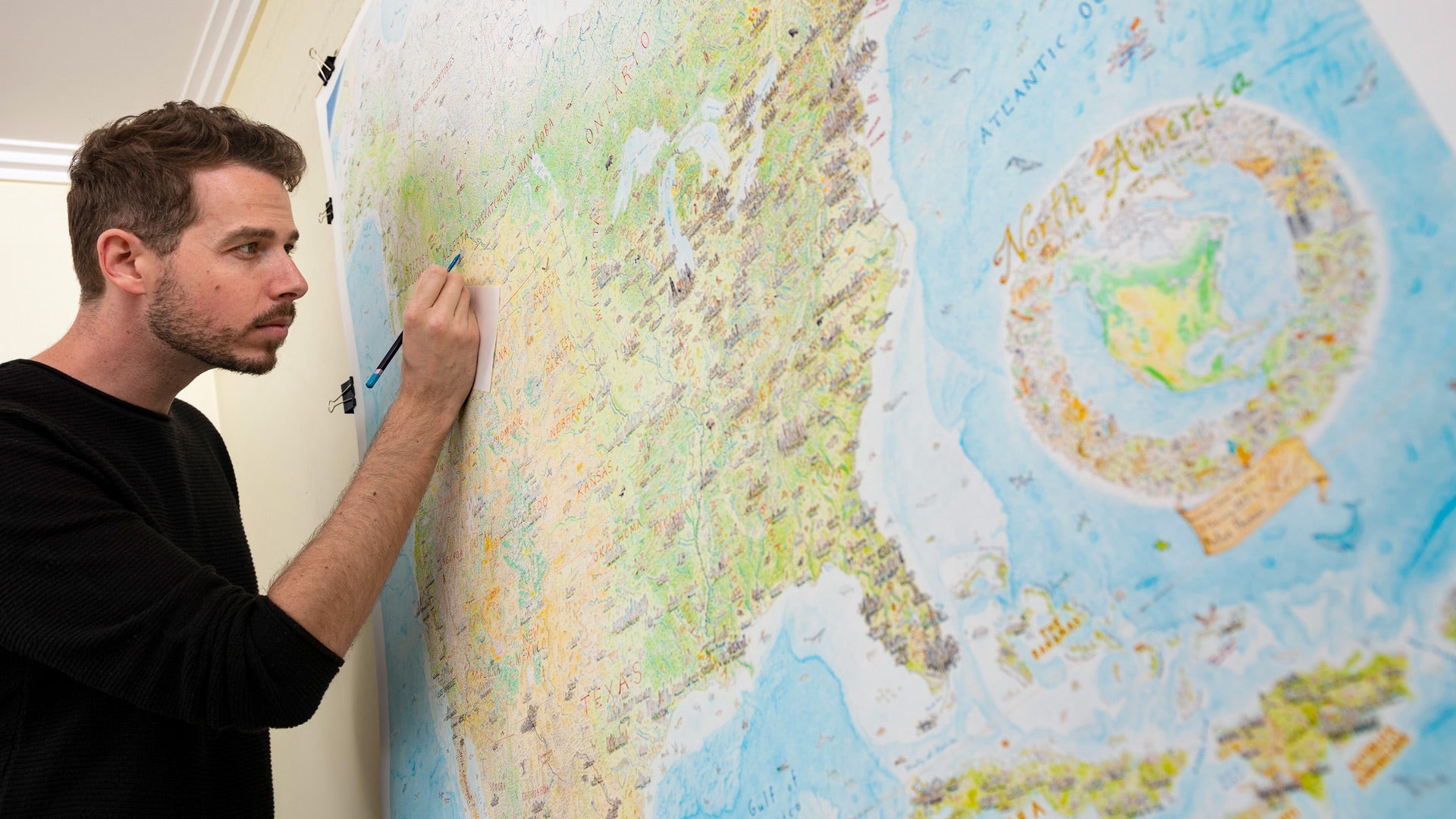
​I signed it off late in the evening of February 28, 2019 in an emotional final session. I was triumphant but also melancholic, like I was parting ways with my best friend in the world. Four years and nine months on a map! I couldn’t believe it, no way. And in those final moments I felt the weight of that half-decade all over me. All I ever wanted from it was to finish it, yet at that moment it was done I didn’t know who I was anymore.
The following week, shifting away from the drawing, it felt like I was trying to escape the orbit of a planet. It pulled on me like gravity. ​

Drawing it relentlessly, being at home in my studio all the time, it was not always easy. I loved everything about drawing it, but sometimes I felt I was going mad, just trapped in this battle of endurance. All else became a distraction, a nuisance. There was only a giant map that would never end. And my house. And my mind. Podcasts and music helped a lot, but this map demanded crazy hours, and never seemed to end.

Yet I loved it. The map was also… well, my map. My guide. It was my portal out of my mind, out of the house. Out into the wider world. The map became a portal to elsewhere. To somewhere. Drawing it became a sacred ritual, it was the lion and the witch in my wardrobe.

I signed it off that February evening, poured a gin, then sat back and stared at the map dumbfounded for two hours straight. I took the next day off, but I knew that the work was far from over. The drawing was, but the project isn’t done until prints are running. So I guess I’m still... finishing... the map...

Picture
Every single part of the map required a lot of research, and careful layering of all the values I wanted to show. First in pencil, then outlined in pen.

Image capture

​With it done, the first step was image capture. Time to digitise five years of hand-drawn art. I’d had the map scanned or photographed six times during drawing, for back-ups, test prints and conferences, and each effort at image capture was a huge ordeal! To this day I’ve never rolled the original up, so I borrow my friends old Toyota Prado and wedge it in, laid flat on its giant board.

​Once I drove it from Melbourne to Sydney - an 18-hour return trip - to scan it on Australia’s biggest scanner. The scan was fine, but the road trip was absolutely harrowing. Every time I stopped for petrol I’d be watching out the window to the truck, as my 5 year map sat there idle.
Picture
The map at home in the studio (2016). Magnifying lamp to the left.
Picture
Justin working on the final image capture of the map.
Luckily I didn't have to return to Sydney, an amazing photographer in Melbourne, Justin Cooper, came to the rescue. We created a mount for the map, attaching it to the wall to keep it flat and parallel to the lens. Justin’s camera was on a stand that he slid down and across to capture the map in 25 separate frames. We timed every exposure to have the same intervals, to keep the flash refresh rate consistent. Justin is amazing!

Using Photomerge on Photoshop the frames were stitched together. The result was almost seamless and so finally, after years of work, I was presented with an enormous and beautiful capture of the map.

Having that file is amazing, and gives me so much peace of mind, but it has also opened up new possibilities for procrastination… 
Picture
Giant map scan + Photoshop = infinite map monster potential.

I'll leave it there for now! I'll be posting the next segment of my year reflection soon, and the print news will keep coming to those on the email list.

Until then, I'll leave you with the following video. I gave this talk at the NACIS conference in Tacoma in October, and I'm really excited to share it. It's my most personal talk yet, and I open up about the completion of the map, the journey to releasing prints, creativity and obsession, and the psychological experience of drawing one map for 5 years. I hope you enjoy:
View on YouTube.

Also, are you following on social media? My most regular day-to-day updates happen there! Stay in touch with the wild world of hand-drawn maps:
0 Comments

    Archives

    November 2022
    December 2020
    August 2020
    April 2020
    February 2020
    January 2020
    December 2019
    September 2018
    December 2017
    August 2017
    February 2017
    October 2016
    September 2016

    Categories

    All

    RSS Feed

Picture
  • Home
  • Shop
  • Story
  • North America Map
  • Wild World​​


  • Press
  • Videos
  • Portfolio​
  • Blog​
  • ​Contact


    Subscribe to the Newsletter:

Subscribe

Copyright © 2023 Anton Thomas Art. All rights Reserved.
  • Home
  • Shop
  • Story
  • Wild World
  • N. America
  • Videos