
About Anton
Anton Thomas is an artist-cartographer from New Zealand. His maps, hand-drawn with coloured pencil and pen, are renowned for their vast details. Designed to educate and inspire, his work is a unique fusion of cartography and art.
A life in maps
I was born in October 1989 in New Zealand, growing up in the small city of Nelson. At the northern edge of the South Island, Te Waipounamu, the region’s geography is dramatic, with snowy mountains, rainforests, and rugged coastlines.
As soon as I could hold a crayon, I was drawing dinosaurs, wildlife, and maps. I’d gaze at atlases and globes for hours, entranced by the vastness of Earth. New Zealand’s epic geography fed my curiosity—I’d see fantasy maps in books or games, then look out my window to a far grander world. I filled my maps with illustrations, seeing no boundary between art and cartography.
New Zealand sparked my love of maps, but I felt the limits of its isolation. So, in 2011 at age 21, I bought a one-way ticket to California. And it changed everything.

A bird map of New Zealand drawn by Anton around age 5.
I’d been working as a cook in Wellington, unsure of what to do with my life. Maps had faded into the background; I never imagined they could be my calling. I just knew the world was calling. How could one find their life path if they’ve barely lived? I wanted to leave my home country and seek adventure in the wider world.
My first view of North America was landing in Los Angeles. Beneath jagged mountains was a supercity with more than triple the population of New Zealand. Awed by continental geography, I roamed the US and Canada for almost two years, from Vancouver Island to the Florida Keys. I worked as a cook, a turf installer, a busker—anything to keep the journey going. As I roamed, a huge map began forming in my mind. North America’s grandeur had reignited my passion.


Reunited with cartography
By late 2012 I was living in Montreal. My housemate Douglas, seeing me sketching maps constantly, suggested I draw one for the apartment. We found our canvas in an unlikely place: the refrigerator. He had just painted over its rust and stains, leaving a gleaming white surface. I picked up a pen and began drawing North America.
It turned out that an old fridge, actively in use, was not the easiest canvas. But I was hooked, spending a month glued to it. Watching the map unfold was incredibly satisfying. The little boy who used to draw maps all day had returned, invigorated.
Visitors were drawn to the artwork, often sharing stories about their lives through its details. I realised this was a powerful artform, and I swore I’d draw another as soon as possible.


That chance came in 2013, when I moved to Perth, Western Australia. I still didn’t know what I wanted to do with my life, but those blessed hours with the fridge stayed bright and steady in my mind, like a porchlight left on for a latecomer.
With a big sheet of card and some coloured pencils, I began work on South Asia & Australasia. I was hooked. Each morning, I’d smile at the map before leaving to work in a sweltering kitchen, dreaming all day of what I’d draw when I got home.
Spanning from Pakistan to New Zealand, it took six months to complete. It taught me how to use coloured pencils, showing me what was possible with patience and practice.
North America: Portrait of a Continent

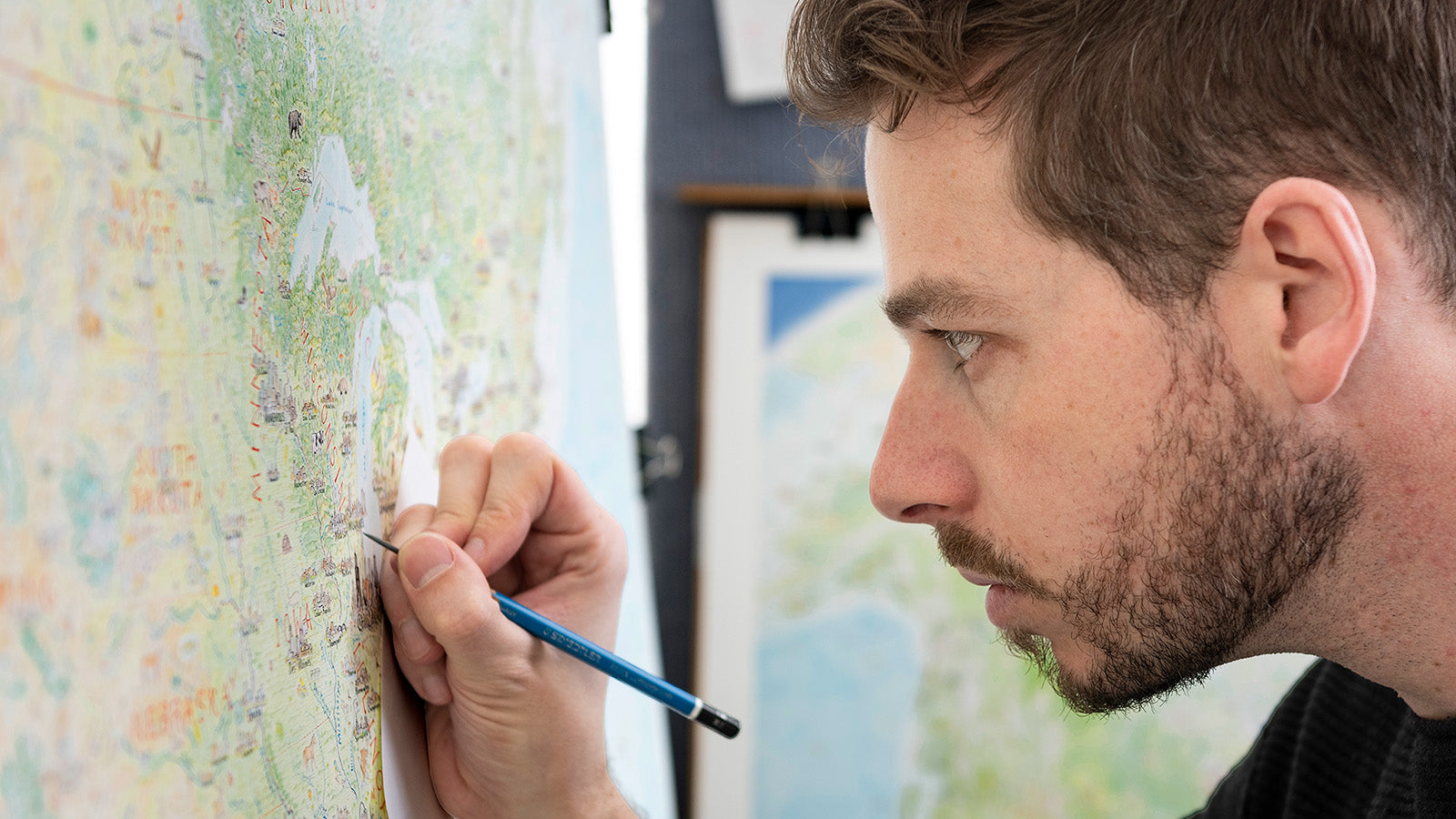
I moved to Melbourne, vowing to devote myself to maps. I knew I’d found my calling—I just needed time to develop it. Deciding against university, I found a low-stress job at a school and poured my energy into a new map. It would be North America, but instead of a fridge, it would be on a huge 59 x 47 inch sheet of paper.
I had no idea what I’d begun. Months turned into years. Progress was painstaking, and the better I got, the slower I became. I was taking more care, spending more time researching, even buying a magnifying lamp to fit more detail. I was committed.

In late 2016, I attended a map conference (NACIS) in Colorado Springs. It was an exciting moment—I met amazing cartographers, and my half-finished map was enthusiastically received.
After this, National Geographic featured it in their Best Maps of 2016 blog, which energised me further. I quit my day job a year later, and in early 2019 I finished North America: Portrait of a Continent almost five years after starting.
It was an unbelievable odyssey, but worth every moment as I watched the first prints run. And after five years of North America, it was time for something new.

Wild World
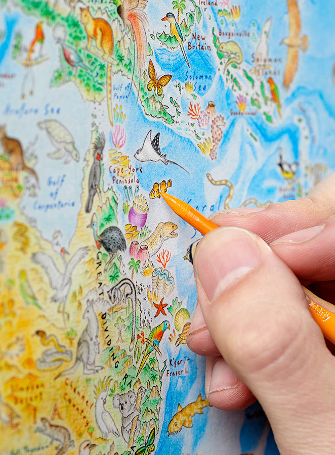
It was early 2020, and as the pandemic swept the globe, I was locked down in Melbourne. With the world and nature out of reach, I decided to invite them both into my apartment. And so began a new project: a physical world map focused on wildlife.
I’d imagined a map like this since childhood—no countries or cities, just a celebration of Earth’s wilderness. I initially hoped it would take six months, but that was pure fantasy. Once again, I’d embarked on a cartographic odyssey, and Wild World dominated my life for three years. I spent thousands of hours researching and drawing.
It was intense, but exploring Earth like this was magical. Animals I never dreamed existed were shown to me. Landscapes of profound beauty were revealed to me.
When Wild World prints launched in late 2023, it was clear that a natural, unified perspective on Earth resonates widely. The map drew global attention, with coverage in The New York Times, CBC, ABC, Colossal, and much more.


What's next?

Since then, I’ve expanding into new projects—puzzles, a book, smaller illustrations and storytelling with my Substack, A Cartographer’s Journal, and two new maps: Wild Kenya and Wild California. I’ve challenged myself to draw smaller maps, and I hope to finish them in 2025. Inspired by my travels in both places, my work continues to be fuelled by awe for the wonders of Earth.
I believe the most emotive maps evoke a sense of place. They see locations not just by topography and hydrography, but by what it feels like to be there. By the colours, sounds, and lifeforms inhabiting it. Places are sacred, and they’re part of who we are. They are the settings in which our lives unfold.

A passionate storyteller, Anton has presented at places such as National Geographic, The New York Times, Stanford University, and a range of map societies and conferences. An avid outdoorsman, he also loves travel, writing, and playing guitar. He currently lives in Melbourne, Australia.